Amboseli Ecosystem Outlook Report July 2025

Preface

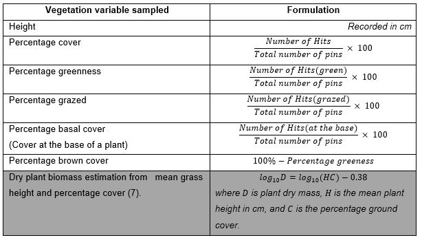
Our Amboseli Conservation Program Outlook Report gives the state of pastures, livestock, and wildlife health across the Amboseli ecosystem as of the end of June. Our ground monitoring and satellite imagery of the pasture and vegetation give an extremely good outlook in the coming dry season through to the short rains later in the year.

The consistent rains from late 2024 through May 2025 produced an excellent crop of grass and strong bush and tree growth. Livestock health and milk yields have recovered fully since the 2023 drought, and market prices for cattle have reached the highest on record due to the shortage of animals and strong national demand for beef. The body condition of wildlife has also fully recovered, signaling a healthy rangeland and steady population recovery now that animals have resumed calving.

Strong Pasture Recovery in Key Swamps

Heavy rainfall has regenerated critical forage zones in the Amboseli Basin. The swamps, which serve as lifelines for both livestock and wildlife, are at peak productivity. This ensures that through the upcoming dry season, there will be sufficient feed to sustain grazing animals without the pressure seen in previous drought years.

The swamps in the Amboseli Basin are critical grazing reserves, providing year-round forage for wildlife and livestock. With the 2025 rains, these areas have reached peak productivity, ensuring grazing stability even as the dry season approaches. This recovery reduces grazing pressure on upland pastures and supports balanced herd distribution across the ecosystem.

Swamp pastures in Amboseli Basin at peak productivity after 2025 rains.

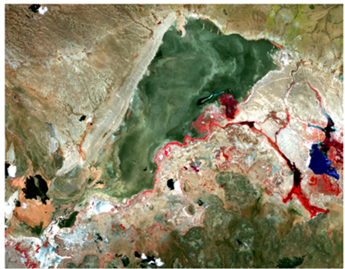
Vegetation Greenness Across the Ecosystem

Satellite imagery from January to June 2025 shows a marked recovery in vegetation greenness (NDVI) across southern Kenya and northern Tanzania. This recovery is significant compared to the severe conditions of 2022–2023. The greenness trends indicate not only good pasture conditions but also improved migration corridors for wildlife.

Satellite-derived NDVI data from January to June 2025 shows a notable rebound in vegetation across southern Kenya and northern Tanzania. The improved greenness reflects not just rainfall recovery, but also effective grazing patterns and ecosystem resilience. This greenness has boosted habitat quality and migration corridors for herbivores moving through Amboseli’s rangelands.

NDVI maps show strong vegetation recovery in Amboseli and surrounding areas.

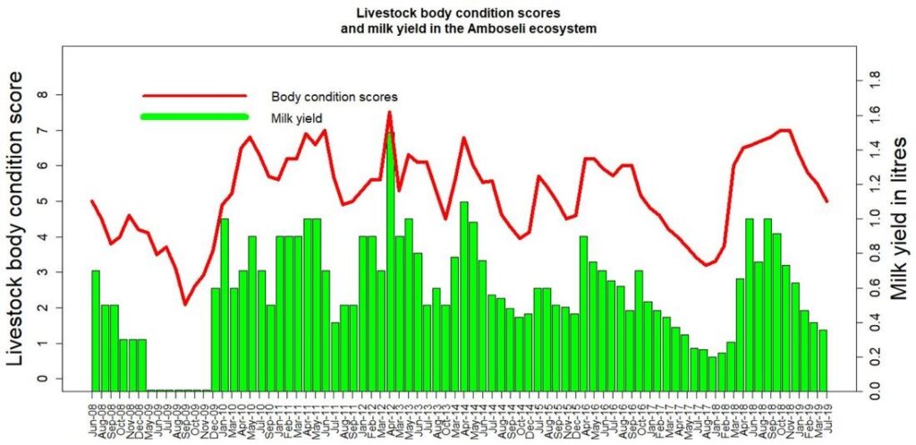
Livestock Health & Market Conditions

Cattle across Amboseli are in peak physical condition. With the strong pasture base and stable water supply, livestock have achieved excellent weight gain. This has driven market prices to historic highs, benefiting local pastoralists who are now able to recover economically after losses during the previous drought.

The improved forage base has translated directly into livestock performance. With abundant grazing and water, cattle are in peak condition, resulting in high milk yields and steady weight gain. These strong conditions have driven record market prices for cattle, boosting incomes for pastoral households recovering from recent drought losses.

Healthy cattle in Amboseli fetching record market prices in 2025.

Conclusion

The 2025 season marks a turning point in Amboseli’s rangeland recovery. Healthy pasture, strong livestock condition, and resilient wildlife populations signal a stable ecosystem heading into the short rains. Continued monitoring through ground surveys and satellite imagery will ensure timely responses to any emerging threats as conditions shift.

Our Team

Ms. Immaculate
Ombongi

Data Analyst

Immaculate is a data analyst at ACP. She has a Bachelors’ degree in Financial Economics from Mount Kenya University.

She is experienced in spatial data analysis and modeling of livestock markets in Kenya. Her interests include GIS, remote sensing, satellite imagery processing and analysis.

Immaculate as well, supports the analysis team that is working on the Rangeland restoration, a program of the African Conservation Centre, also known as the JUSTDIGGIT project.

Our Team

Ms. Immaculate
Ombongi

Data Analyst

Immaculate is a data analyst at ACP. She has a Bachelors’ degree in Financial Economics from Mount Kenya University.

She is experienced in  spatial  data analysis and modeling of  livestock markets in Kenya.  Her interests include GIS, remote sensing, satellite imagery processing and analysis.

Immaculate as well, supports the analysis  team  that is working on the Rangeland restoration, a program of the African Conservation Centre, also known as the JUSTDIGGIT project.

Our Team

Mr. Sakimba
Kimiti

Assistant Researcher

Sakimba is currently pursuing a PhD at the University of Lyon 2 in France. He previously worked as an Assistant Researcher for the Amboseli Conservation Program.

He holds a Bachelor of Science (Wildlife Management and Conservation) degree from the University of Nairobi and  a Master of Science degree in Range Management from the same University.

Prior to joining the ACP, he worked as an Ecological Assistant at South Rift Land Owners Association. At ACP, he is involved in projects dealing with the Dynamics of Predation on Spatial -temporal Basis and in Human Ecology.

His other interests include: GIS, remote sensing, satellite imagery, ecological monitoring, land use change and ecosystem vulnerability.

Our Team

Ms. Winfridah
Kemunto

Database Administrator

Winfridah  is the  Amboseli Conservation Program’s database Administrator. She has a certificate from Pitman Training Institute and vast experience in working with big data that involve database management,  basic analysis, digital library, data mining and  data visualization.

Her interests include spatial data mining and presentation.  Before Joining ACP, she worked  as a data clerk at South Rift Land Owners Association (SORALO).

Our Team

Mr. David
Maitumo

Field Officer/ Data Collector

David has been working in Amboseli as the ACP field officer since 1977. As a member of the local Maasai community in the Amboseli area, David brings a unique perspective to the program.

His rich understanding of the interaction of people, livestock, and wildlife, and the challenges facing conservation in human landscapes, enriches his key roles in the design of field experiments and long term data collection and monitoring.

Our Team

Dr. David
Western

Founder & Chairman

Dr. David Western, known as Jonah, began research into savannas ecosystems at Amboseli in 1967, looking at the interactions of humans and wildlife.

His work, unbroken since then, has served as a barometer of changes in the savannas and test of conservation solutions based on the continued coexistence of people and wildlife.

Jonah is currently chairman of the African Conservation Centre, Nairobi. He directed Wildlife Conservation Society programs internationally, established Kenya’s Wildlife Planning Unit, chaired the World Conservation Union’s African Elephant and Rhino Specialist Group, and was founding president of The International Ecotourism Society, chairman of the Wildlife Clubs of Kenya, director of Kenya Wildlife Service, and founder of the African Conservation Centre in Nairobi.

He is an adjunct professor in Biology at the University of California, San Diego.

Western’s publications include;

Conservation for the Twenty-first Century (OUP, 1989), Natural Connections: Perspectives in Community-based Conservation (Island Press, 1994) and In the Dust of Kilimanjaro (Shearwater, 2001).

He is presently conducting a study on climate change in the Kenya-Tanzania borderlands in collaboration with University of California San Diego, University of York, Missouri Botanical Gardens, and African Conservation Centre.

Our Team

Dr. Victor N.
Mose

Deputy Director & Head of Bio-statistical Services

Dr. Victor N. Mose is the Deputy Director and Head of Biostatistical Services. He was awarded a PhD in Biomathematics by the University of Pierre and Marie Curie (UPMC), Paris VI, France in 2013.

He has a Masters in bio-statistics from the University of Nairobi, Kenya and a Bachelors degree in Mathematics from the same University.

He also holds a financial mathematics qualification from the Institute of Actuaries, London, UK.

Victor is experienced in ecological modeling, bio-informatics, and geographical information systems (GIS).

His research interests include Population dynamics, migration modelling, Bayesian spatial analysis, ecosystem services and economics modelling, together with biodiversity mapping.

Victor’s publications include;

Mose, V.N., Nguyen-Huu, T., Auger, P., Western, D. 2012. Modelling herbivore population dynamics in the Amboseli National Park, Kenya: Application of spatial aggregation of variables to derive a master model. Ecological Complexity, 10, 42-51.

Figure 12:Illustration of how the monthly total count of keystone species is conducted within the Amboseli basin area that includes that protected Amboseli National Park. The counts are done on a one-by-one km grid system.

Figure 1: Amboseli National Park is surrounded by Maasai group ranches. ACP has conducted aerial surveys of the 8,500 square kilometers eastern Kajiado region since 1973 using a 5 x 5 kilometer-square grids to count and map wildlife and livestock. The brown box (migration area) defines the Amboseli ecosystem—the seasonal range of the migratory wildlife populations using Amboseli National Park and permanent swamps in the dry season. Ground vegetation monitoring is done at basin area surrounding the Park and in selected group ranches (Olgulului, Kimana, Eselenkei and Mbirikani).

Figure 9 : Livestock body condition scores and milk yield in the Amboseli ecosystem

Figure 8: Counting of all herbivore species (including livestock) seen over the 500m radius from the centre of the plots scattered across the Amboseli ecosystem .

Table 1: Calculations and estimates of vegetation variables collected in the permanent plots in the basin and the surrounding group ranches.

Figure 5: Percentage cover showing number of hits, misses and total number of pins captured. For instance, percentage cover here is calculated as: (Number of Hits)/(Total number of pins) × 100, which gives, 5/9 × 100=55.6. The grass height is recorded in cm.

Figure 3: Ground vegetation monitoring in selected group ranches. The plots where monitoring is done within the ranches are also shown.

Figure 2: Major habitats amalgamated into eight habitats from 29 vegetation zones defined in the 1967 baseline and subsequent surveys. The 10m radius permanent plots monitored every 4 to 6 weeks are shown. The 20 vegetation plots were selected from a randomized set of 101 original plots. (4)

Table 4: Some satellites and their Spatio-temporal resolution

Figure 15: A screenshot of Google Earth showing human settlement locations in the Amboseli basin area. The red placemarks show occupied settlements while the yellow ones represent the unoccupied

Figure 16: Detected bomas identified by the use of Machine Learning in the Amboseli basin area.

Figure 17: A recent sample of the Sentinel 2 image obtained for processing of the vegetation zones of the Amboseli basin area. The swamp habitat is reasonably distinguished by color red.

Figure 18: Historical changes in the Amboseli basin vegetation from aerial photography mapping that are currently being updated using satellite imagery.