Tracking Amboseli's Shifting Landscapes
The Amboseli ecosystem is changing fast in climate, vegetation, land use, and in how people and wildlife move across the land. These changes affect biodiversity, water resources, and traditional pastoral livelihoods. This monitoring program helps communities and conservationists track these changes and respond wisely.
Our Mission
To generate open-access ecological and social data that supports community decision-making and builds resilience in the Amboseli landscape.
Video Credit : Mark Manongdo
Rangeland Health
Every grain  of soil
holds a story. We empower
of soil
holds a story. We empower  communities to uncover it.
Our Team
Our strength lies in the dedication and expertise of the people behind ICoSS. From ecologists and data scientists to community liaisons, each member plays a vital role in shaping conservation strategies for the Amboseli ecosystem.
Our Programs
Our programs combine science, community knowledge, and technology to safeguard Amboseli’s ecosystems. From tracking vegetation change to supporting local communities, each initiative is designed to provide actionable data and sustainable solutions.
01
Our Programs
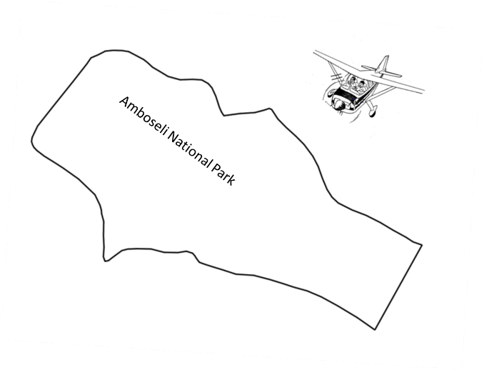
Aerial
Monitoring
We use regular aerial surveys to monitor vegetation, livestock, and wildlife across the Amboseli ecosystem, capturing critical data on patterns of movement, habitat conditions, and seasonal shifts.
These surveys provide essential insights that highlight areas of heavy use or degradation, guide restoration efforts, and support informed decision-making by the communities.
01
Our Programs
Aerial
Monitoring
We use regular aerial surveys to monitor vegetation, livestock, and wildlife across the Amboseli ecosystem, capturing critical data on patterns of movement, habitat conditions, and seasonal shifts.
These surveys provide essential insights that highlight areas of heavy use or degradation, guide restoration efforts, and support informed decision-making by the communities.
02
Our Programs
Ground
Monitoring
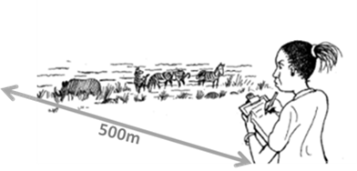
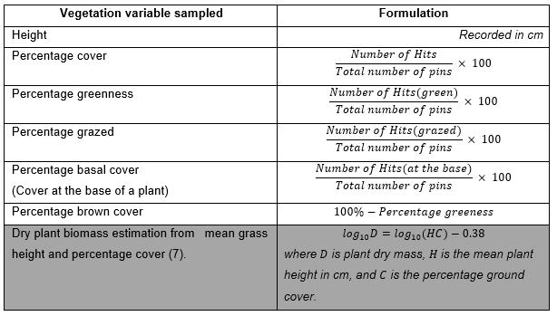
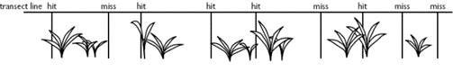
We conduct regular ground-based monitoring to collect detailed, on-the-ground observations of vegetation, livestock, and wildlife across the Amboseli ecosystem.
These field assessments provide vital context to aerial data, capturing fine-scale changes, verifying remote sensing results, and supporting informed decisions by communities, conservationists, and land managers.
02
Our Programs
Ground
Monitoring
We conduct regular ground-based monitoring to collect detailed, on-the-ground observations of vegetation, livestock, and wildlife across the Amboseli ecosystem.
These field assessments provide vital context to aerial data, capturing fine-scale changes, verifying remote sensing results, and supporting informed decisions by communities, conservationists, and land managers.
03
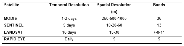
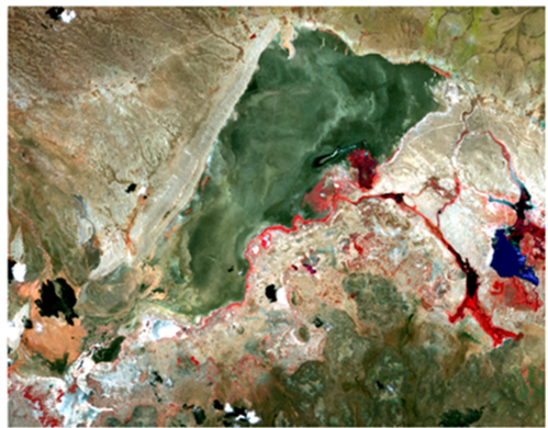
Our Programs
Satellite Monitoring
We use satellite imagery to monitor vegetation, land use, and environmental changes across the Amboseli ecosystem with high temporal and spatial accuracy.
This long-term perspective reveals seasonal patterns, tracks habitat shifts, and provides reliable data that supports conservation planning, policy development, and adaptive management strategies.
03
Our Programs
Satellite Monitoring
We use satellite imagery to monitor vegetation, land use, and environmental changes across the Amboseli ecosystem with high temporal and spatial accuracy.
This long-term perspective reveals seasonal patterns, tracks habitat shifts, and provides reliable data that supports conservation planning, policy development, and adaptive management strategies.
Ecosystem News
Our Ecosystem News section keeps stakeholders updated on Amboseli’s dynamic environment. These insights support evidence-based conservation decisions and inform community action.
- David Western, Victor N. Mose & The ACP Team
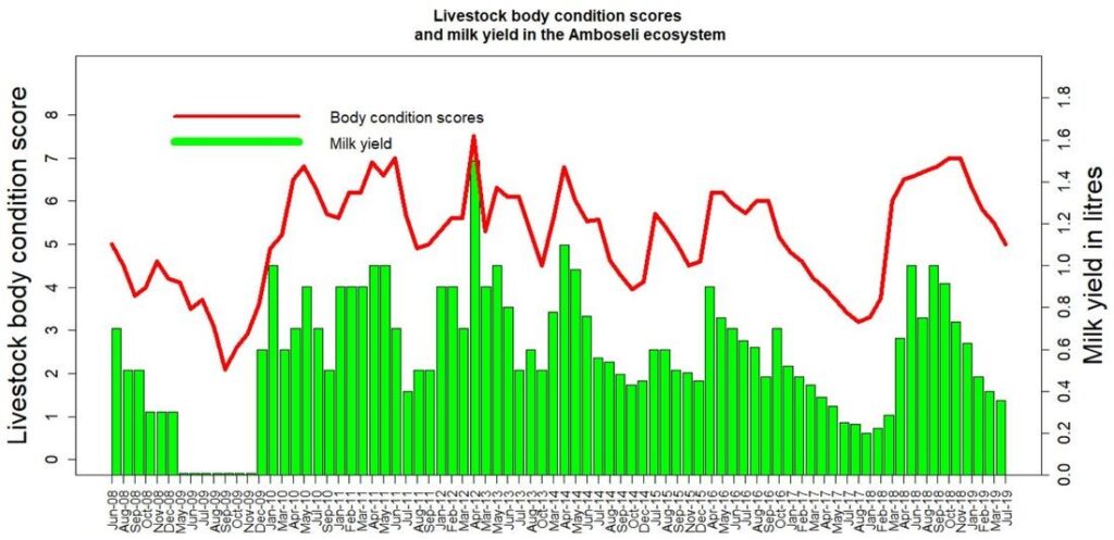
Forage is abundant after heavy rains (late-2024/May-2025). Wildlife and livestock have recovered from the 2023 drought, cattle prices are high, and the dry season outlook is strong.
- David Western, David Maitumo, Victor N. Mose, Julius Muriuki and Glen P. Mitema
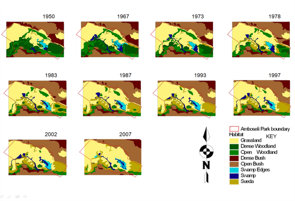
Six decades of mapping show fever trees declining due to elephants, creating grassland. Human pressure now rivals rainfall in shaping vegetation.
- Victor Mose
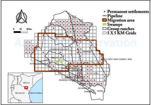
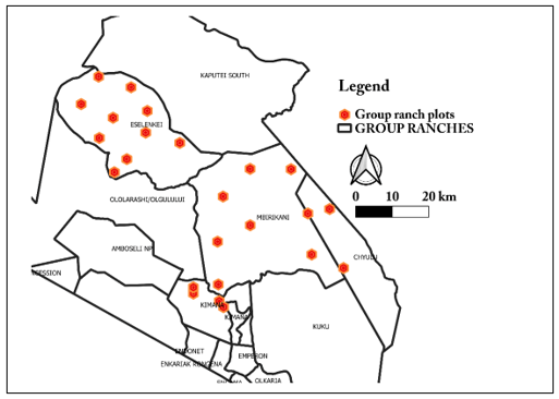
ACP and ACC launched a 330-household survey in Amboseli, combining ground interviews with GEDI satellite data, and will add women assessors and a NASA-funded weather station.
Tracking Amboseli's Shifting Landscapes
The Amboseli ecosystem is changing fast in climate, vegetation, land use, and in how people and wildlife move across the land. These changes affect biodiversity, water resources, and traditional pastoral livelihoods.
Rangeland Health
Every grain of soil
holds a story.
01
Our Programs
Aerial
Monitoring
We use regular aerial surveys to monitor vegetation, livestock, and wildlife across the Amboseli ecosystem, capturing critical data on patterns of movement, habitat conditions, and seasonal shifts.
These surveys provide essential insights that highlight areas of heavy use or degradation, guide restoration efforts, and support informed decision-making by the communities.
02
Our Programs
Ground
Monitoring
We conduct regular ground-based monitoring to collect detailed, on-the-ground observations of vegetation, livestock, and wildlife across the Amboseli ecosystem.
These field assessments provide vital context to aerial data, capturing fine-scale changes, verifying remote sensing results, and supporting informed decisions by communities, conservationists, and land managers.
03
Our Programs
Satellite Monitoring
We use satellite imagery to monitor vegetation, land use, and environmental changes across the Amboseli ecosystem with high temporal and spatial accuracy.
This long-term perspective reveals seasonal patterns, tracks habitat shifts, and provides reliable data that supports conservation planning, policy development, and adaptive management strategies.
Our Team
Our strength lies in the dedication and expertise of the people behind AEM.